What the maps reveal
A park that shrank — and maps that record exactly when
Maps do not lie. They record what existed at the moment of survey — the boundary of a field, the footprint of a building, the presence or absence of a bandstand. When those maps are laid across one another in sequence, they tell a story that no document can obscure.
The series of maps below covers Verdin Park from 1850 — before it was a park at all — through to the present day. Together, they establish the original extent of the land gifted to the people of Northwich in 1887, confirm that the park remained intact for over eighty years, and pinpoint the period — between 1970 and 1973 — when its western boundary was permanently breached.
The maps are drawn from Ordnance Survey archives, the Cheshire Tithe Map record (EDT 436/2), and aerial photography. OS maps for 1908–2026 are reproduced for research and educational purposes.
Key findings
The gifted estate covered approximately 14 acres — the Winnington Bank house grounds plus the Neumann field to the west.
Every Ordnance Survey map in this period shows the park boundary and bandstand intact. No encroachment for over 60 years.
The western strip was taken for the hospital car park. The bandstand was demolished in the same period.
The park is measurably smaller than it was when gifted. The proposed new car park site sits on what remains.
1850 — The Tithe Map
The Cheshire Tithe Map (EDT 436/2) shows the area nearly forty years before Verdin Park existed. The land that would become the park belonged to a local lawyer named Thomas J B Hostage.
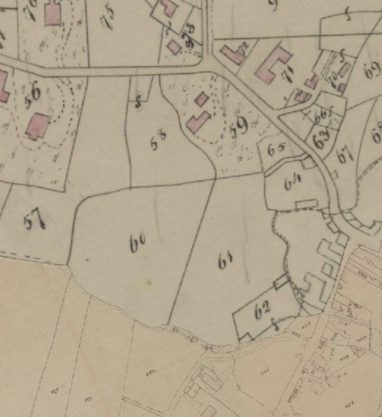
The Tithe Map — field numbers
Cheshire Tithe Map EDT 436/2. Plot 59 (centre) is the Winnington Bank estate. Plots 64 and 65 front Winnington Street.
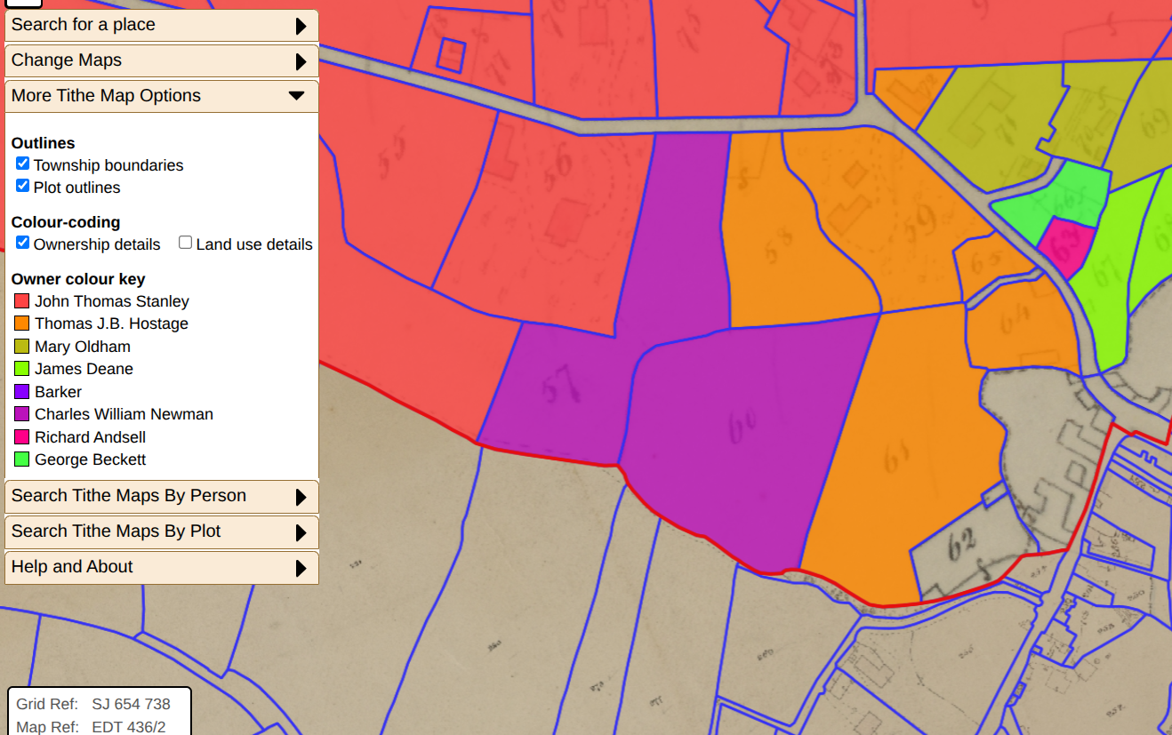
Ownership colour-coding
Thomas J B Hostage owned the main estate (plot 59) and two smaller plots. The Newman family owned the adjoining western field — later purchased by Joseph Verdin in 1888 to complete the 14-acre gift.
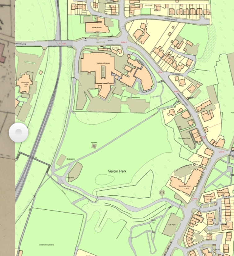
1850 boundaries on a modern map
The 1850 tithe parcel boundaries overlaid on OpenStreetMap. The park sits clearly within the former Hostage estate, with the Newman field completing the full 14-acre extent.
Winnington Bank House
In 1850, the land was known as the Winnington Bank estate — a private residence shown on maps as early as the Greenwood survey of 1819. Thomas J B Hostage, a local lawyer and Clerk to the Trustees of the River Weaver, occupied Winnington Bank House with his family. The estate included the house, its formal gardens, kitchen gardens, bowling greens and glasshouses.
The 1884 auction and Verdin's purchase
Following Mrs Hostage's death, the estate was auctioned in 1884 as lots 26–29, described as suited for a hydropathic establishment. Robert Verdin purchased it at auction. Three years later, in January 1887, he announced his intention to give the entire estate to the people of Northwich — the house as a public infirmary, the grounds as a public park and brine baths.
1908 — The Park in its Original Form
The 1908 Ordnance Survey map is the definitive record of Verdin Park as it was created. Every major feature of the original gift is visible.
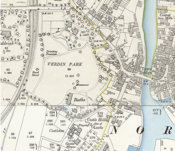
Ordnance Survey, 1908 — Verdin Park, Northwich
“Verdin Park” labeled. The baths are clearly marked north of the Castle Street path. The bandstand is marked at the top of the upper lawn. The Verdin monument is shown at the centre of the park. The western boundary — against the railway line — is intact.
What the 1908 map establishes
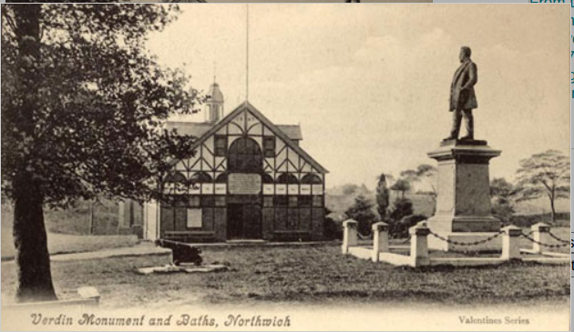
“Verdin Monument and Baths, Northwich” — Edwardian postcard (Valentines Series)
The timber-framed baths building (background), Robert Verdin statue (right), and Crimean War cannon (foreground). The baths closed in 1911 after catastrophic ground subsidence opened a 29-foot cavity beneath them.
1954 & 1961 — The Park Survives
Two mid-century Ordnance Survey maps confirm that the park and its western boundary remained intact through the Second World War and into the early 1960s.
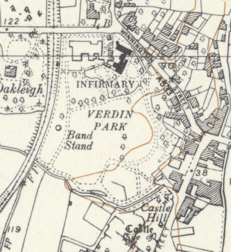
Ordnance Survey, 1954
“Verdin Park” labeled. “Band Stand” labeled — still standing a decade after the war, during which sandbags had been piled around it to protect the Infirmary windows from blast. The western boundary is unchanged from 1908.
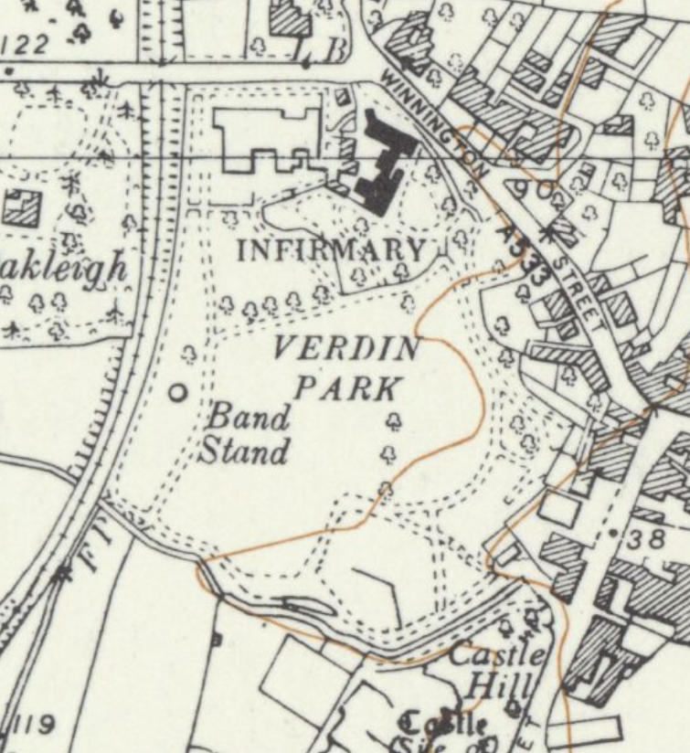
Ordnance Survey, 1961
“Verdin Park” and “Band Stand” both labeled. No encroachment on the western boundary. The Victoria Infirmary is shown at the northern edge but its footprint has not extended into the park.
Over sixty years of continuity. From the original gift in 1887 to the 1961 OS survey, every map shows the park boundary intact and the bandstand in place. There is no evidence of any encroachment, reduction, or boundary alteration in this entire period.
1970 — The Final Survey Before the Change
The 1970 Ordnance Survey is the last map to show Verdin Park as originally gifted — with the bandstand in place and the western boundary fully intact.
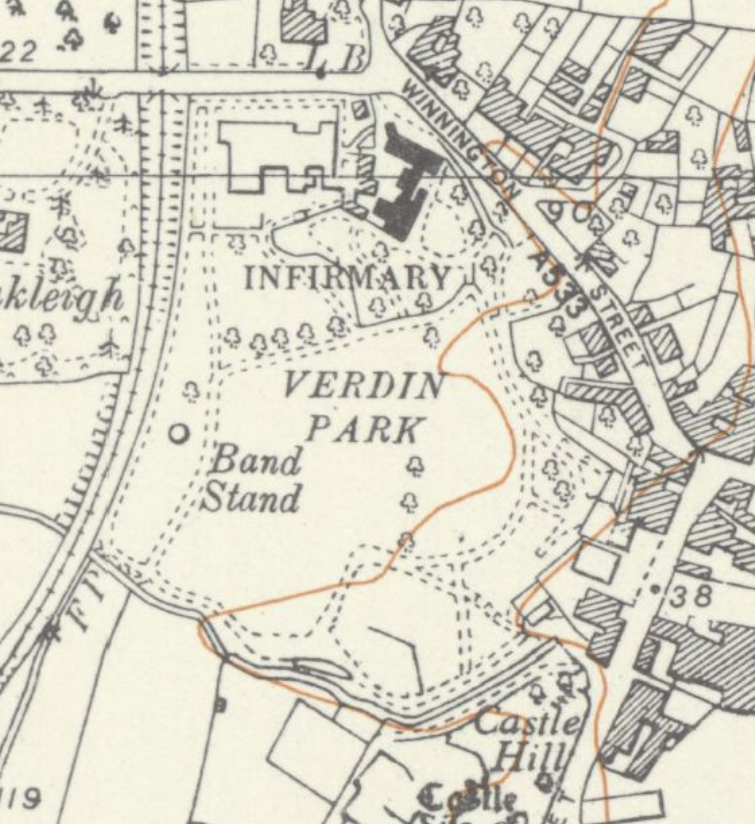
Ordnance Survey, 1970
The last OS map to show the bandstand labeled within the park. The western boundary — against the railway — remains intact. Between this survey and the 1973 aerial photograph, everything changed.
The 1970 OS map is significant not for what it shows, but for what came after it. In the space of two to three years following this survey, the park's western strip was taken by the hospital, the bandstand was demolished, and a car park was constructed on the land.
The 1970 map records a park that had stood largely unchanged for 83 years. No other OS survey captures the bandstand after this date. No later map shows the western boundary intact.
What happens next
Last OS map — bandstand and western boundary intact
Bandstand demolished. Hospital boundary extended to the railway. Car park under construction.
Aerial photograph shows the new car park complete — on former park land
c.1973 — The Aerial Photograph
An aerial photograph from approximately 1973 captures the moment of change — the hospital's boundary already extended to the railway, the car park under construction on what had been the park's western strip.
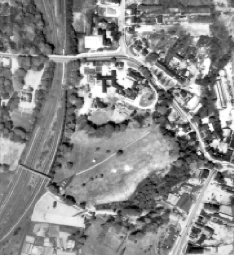
Aerial photograph, c.1973
The hospital boundary has already been extended to the railway line. A car park is under construction on what had been the park's western strip — the same ground where the Victorian bandstand stood. The bandstand has already been demolished.
This aerial photograph is the pivotal document in the map sequence. Between the 1970 Ordnance Survey and this photograph, the park's western strip was taken. The car park visible under construction occupied land that formed part of the original 1887 Verdin gift — the same area where the Victorian bandstand had stood for eighty years.
The Cheshire Gardens Trust report (2021) confirmed this directly:
“The area occupied by the kitchen garden and then developed as bowling greens and tennis courts has been totally developed with additional infirmary facilities and car parking.”
Cheshire Gardens Trust — Verdin Park Research Report (2021)
What was lost
The Victorian bandstand — demolished
The kitchen garden of Winnington Bank House
The bowling greens and tennis courts
The park's original western boundary
2026 — Today
The current Ordnance Survey map shows the park in its reduced form — the result of the 1970s encroachment. Compare it with the 1908 map to see what changed.
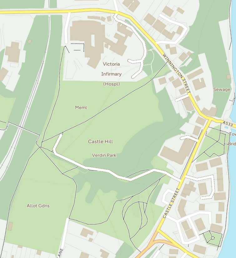
Ordnance Survey, 2026
The park today. The Victoria Infirmary complex and its existing car park occupy the north-western section that was part of the original gift. The bandstand is gone. The proposed new car park site is immediately to the south of the existing hospital buildings — within what remains.
The 2026 map shows the park as it is now — measurably smaller than it was when the Verdin family made their gift in 1887. The land register for Northwich Town Council (title CH583585) reflects the already-reduced park footprint. The area taken in the 1970s is now part of the hospital's registered title.
Whether the 1970s land-take was ever formally authorised — and under what legal instrument — remains an open question. FOI requests submitted in June 2026 seek to establish this from NTC, CWaC and MCHFT records.
The concrete slab — what remains
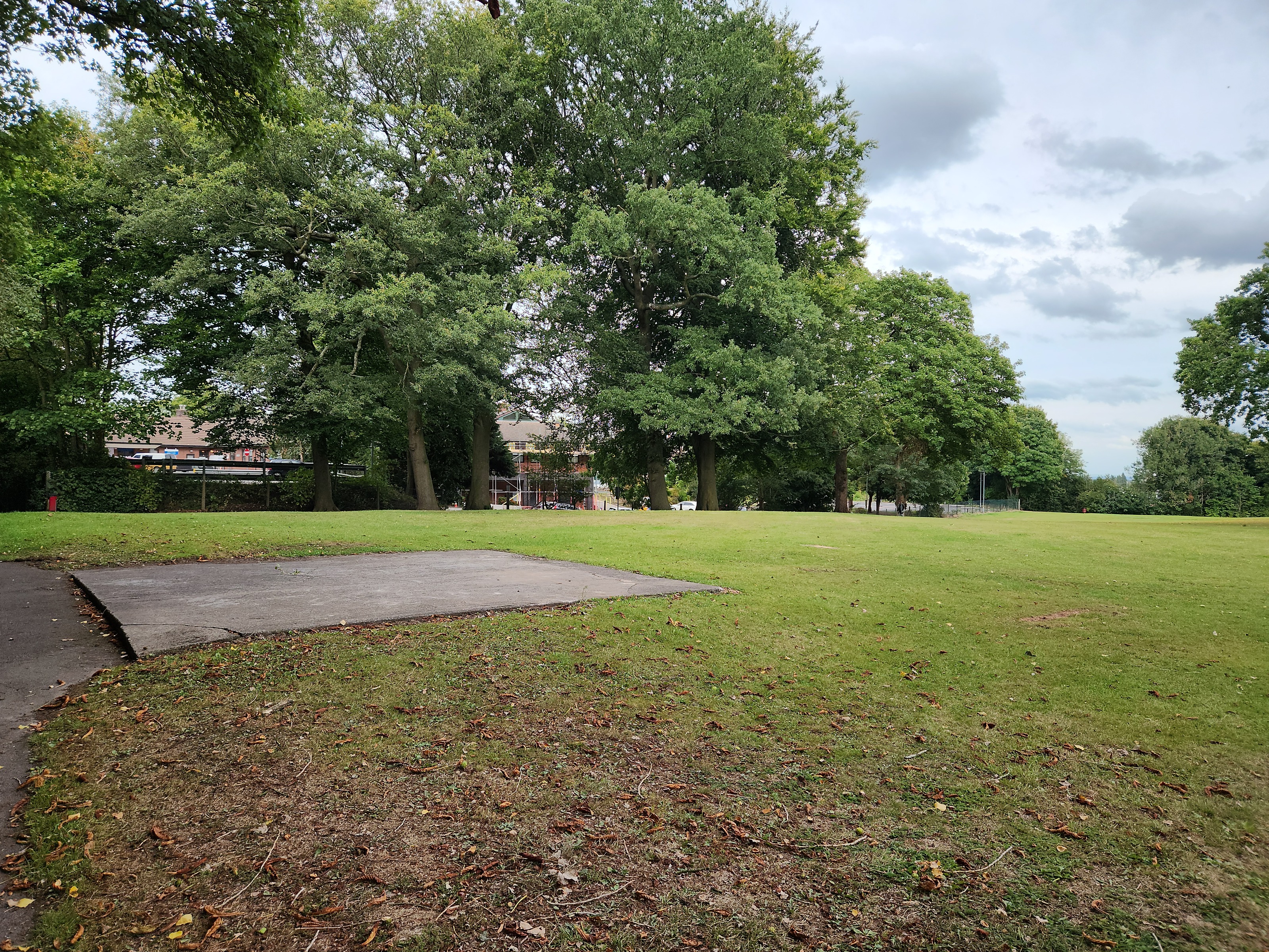
The concrete foundation of the Victorian bandstand is still visible in the ground, September 2025. The Victoria Infirmary is visible through the trees behind it. This is the area now proposed as an overflow car park.
What the maps establish — at a glance
| Date | Bandstand | Western boundary | Baths |
|---|---|---|---|
| 1850 | Not yet built | Original 14-acre Hostage + Neumann estate | Not yet built |
| 1887 | Announced (built c.1890) | Gift deed executed — full 14-acre gift | Opened October 1887 |
| 1908 OS | ✓ Present and labeled | ✓ Intact — full original boundary | ✓ Present and labeled |
| 1954 OS | ✓ Present and labeled | ✓ Intact | Demolished 1912 |
| 1961 OS | ✓ Present and labeled | ✓ Intact | — |
| 1970 OS | ✓ Last map to show it | ✓ Intact — last complete map | — |
| c.1973 aerial | ✗ Demolished | ✗ Breached — car park under construction | — |
| 2026 OS | ✗ Gone (slab remains) | ✗ Permanently lost — western strip is hospital land | — |
Explore further
More from the history of Verdin Park
1890 — Lost
The Bandstand
The octagonal Victorian kiosk, built to be raised on screw jacks — and how it disappeared.
1887 — 1912
The Verdin Baths
A Victorian brine pool, 20,000 visitors a year, a champion swimming club — and its spectacular end.
1887 — Today
Full History
The complete story of Verdin Park — salt, philanthropy, and 130 years of community life.
Help protect what remains
The maps show what was lost in the 1970s. Friends of Verdin Park exists to ensure no further ground is given up. Join us to help protect the park for everyone, for always.